

/https%3A%2F%2Fprofilepics.canalblog.com%2Fprofilepics%2F1%2F1%2F116167.jpg)
/https%3A%2F%2Fstorage.canalblog.com%2F49%2F16%2F312499%2F14620054_o.jpg)
/https%3A%2F%2Fstorage.canalblog.com%2F53%2F18%2F312499%2F14151229_o.jpg)
/https%3A%2F%2Fstorage.canalblog.com%2F07%2F05%2F312499%2F14149867_o.jpg)
/https%3A%2F%2Fstorage.canalblog.com%2F11%2F35%2F312499%2F14149307_o.jpg)
/https%3A%2F%2Fstorage.canalblog.com%2F90%2F14%2F312499%2F14125247_o.jpg)
Neolithic Skara Brae, Broch of Gurness, villages

 Skara Brae is a very important archeological site located on the Western coast of the principal island of the Orkneys.
It includes/understands the remainders of a Neolithic village which thanks to their hiding in sand spent the centuries without suffering important damage. The state of conservation is so exceptional that this site was registered on the list of the world inheritance by UNESCO.
 Until
1850, Skara Brae remains hidden under dunes not far from the beach.
This year, a particularly agitated sea and winds violent one tore off
grass and released several constructions; in 1924 of the similar
weather conditions completed to update the vestiges of the village.
Although the site knew several periods of occupation and dwelling,
which in is visible today goes up with most recent of them.
Until
1850, Skara Brae remains hidden under dunes not far from the beach.
This year, a particularly agitated sea and winds violent one tore off
grass and released several constructions; in 1924 of the similar
weather conditions completed to update the vestiges of the village.
Although the site knew several periods of occupation and dwelling,
which in is visible today goes up with most recent of them.
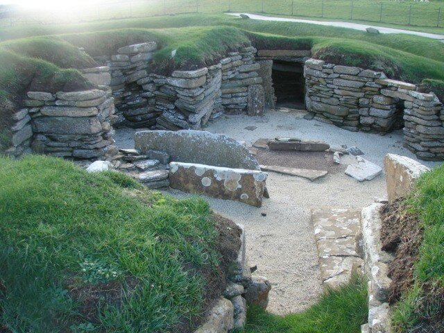
The similar foundations of eight residences, joined together by a series of low alleys, were completely discovered between 1928 and 1930.

The number of inhabitants of Skara Brae probably never exceeded 50 to 100 units for the same period. Apparently these inhabitants manufactured and used potteries of the type “Grooved Ware”. The walls and the roof of the houses were covered with ground but, rather than to be hidden in the ground, they were built starting from monticules of preexistent waste called “middens” which is made up various elements (refuse, broken potteries, bone, shells and remainders of animals…). Although this “midden” gets only one low stability with constructions, its principal utility was to provide a good insulation to the dwellings subjected to the hard winter climate of the Orkneys.
The houses, of an average surface of 40 square meters, had a broad square room containing a large hearth which was to be used to make the kitchen and to heat itself. As there were few trees on the island, the people of Skara Brae used wood brought by the ocean, of the pennons of whale and the thatch of grass to cover their houses.
The residences contain a certain number of pieces of furniture built out of stone such as cupboards,  the
convenient ones, seats and beds closed (bordered of broad stones). The
village profited even from a sophisticated system of drains which
included can be the primitive shape of toilets in each housing.
the
convenient ones, seats and beds closed (bordered of broad stones). The
village profited even from a sophisticated system of drains which
included can be the primitive shape of toilets in each housing.
It is thought that the site of Skara Brae was occupied during roughly 600 years from -3100 and to the surroundings of -2500. At that time the climate east cools and became wetter, involving the abandonment of the site by its inhabitants. (wikipédia)
Another explanation of the desertion from the village is the emergence of a regional group causing the collapse of the old Community organization which had developed in autonomous villages. The new order could call into question the need for living in very closed villages. Balance between needs for the cell familliale and community could be upset by the establishment of the regional group.
The individual family had become more important, whereas the community life was it less. People are alorsremis with living in isolated farms, each one of them being considered from now on as component of the régionnal group to which it was identified. Consequently, gradually, Skara Brae has abandoned being.
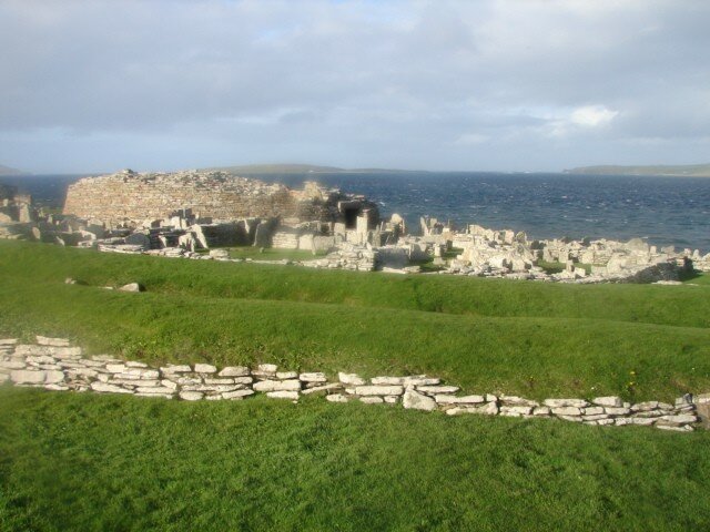

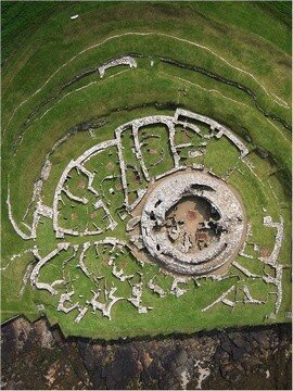
Broch is a fortification built at the time prehistoric which one finds in great number in north of Scotland and in the Orkneys.
The brochs are constructions of the age of iron, which have approximately 2.500 to 3.000 years. Composed generally of a double enclosure, they are massive circular towers comprising two stages and being able to rise with more than 15 meters to the top of the ground.
 Around,
as in Gurness, one can find the remainders of a habitat. The broch,
ancestor undoubtedly of the strong castle, could be used to shelter the
population at the time of the tribal conflicts.
Around,
as in Gurness, one can find the remainders of a habitat. The broch,
ancestor undoubtedly of the strong castle, could be used to shelter the
population at the time of the tribal conflicts.
It is thought that some brochs were built by Pictes.
 Built between 200 and 100 front J-C, Broch de Gurness (Broch of Gurness)
rose at the origin to 8 m in height. The entry opens in the principal
room, where is the rectangular hearth. Its double stone wall dries
ensures solidity and stability to him: the two walls separated by a
vacuum, are connected to regular intervals by large stones. Between the
two thicknesses of the wall, small driving a snail stone cells and
staircase are arranged on the floor higher then than the roof. In the
underground room which one reaches by stone steps, a water tank of
source.
Built between 200 and 100 front J-C, Broch de Gurness (Broch of Gurness)
rose at the origin to 8 m in height. The entry opens in the principal
room, where is the rectangular hearth. Its double stone wall dries
ensures solidity and stability to him: the two walls separated by a
vacuum, are connected to regular intervals by large stones. Between the
two thicknesses of the wall, small driving a snail stone cells and
staircase are arranged on the floor higher then than the roof. In the
underground room which one reaches by stone steps, a water tank of
source.
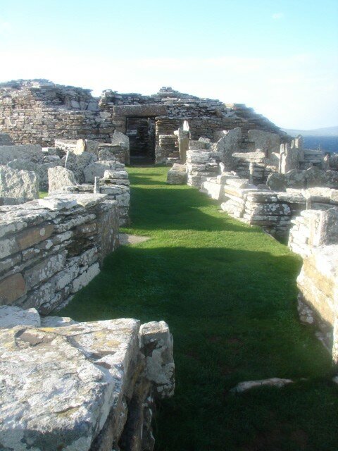
Small dwellings laid out around the broch, the interior fitting is discovered: site of the central hearth, niches of arrangement arranged in the stone walls… The village which lodged forty families, is surrounded by three defensive ditches alternating with three slopes. Its situation is strategic: the boats which passed in Eynhallow Sound, arm of the sea between Gurness and the islands of Rousay, Wyre and Eynhallow, could not miss being located. Pictes initially, then the Vikings used this site: the excavations put at the day a house picte (Shamrock House) and many Vikings objects which are today with the Museum of Tankerness House in Kirkwall.
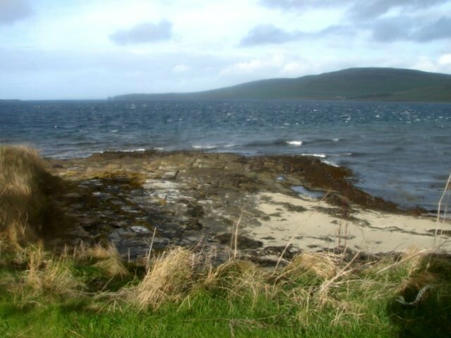
What do you come to make Neolithic villages in a site on the crowned spot, will say to me?
 And
well, it is quite simply because I felt it thus. It was to exist in
these villages of the priests informed well of crowned, is to to me
opinion… Far from the explanations which one wants to give us well, I
think that this village was much more than one regrouping of houses.
And a broch, is this really the ancestor of the castle-extremely? Me I
will lean more for one crowned place, like the cathedral posed in the
center of the city. And would be this only for the formidable energy
which left me pantelante on the strike, in front of the rocks beaten by
the winds and tides. Hold, cups, signs engraved on the rock… But it is
not marked in the handbook, that???
And
well, it is quite simply because I felt it thus. It was to exist in
these villages of the priests informed well of crowned, is to to me
opinion… Far from the explanations which one wants to give us well, I
think that this village was much more than one regrouping of houses.
And a broch, is this really the ancestor of the castle-extremely? Me I
will lean more for one crowned place, like the cathedral posed in the
center of the city. And would be this only for the formidable energy
which left me pantelante on the strike, in front of the rocks beaten by
the winds and tides. Hold, cups, signs engraved on the rock… But it is
not marked in the handbook, that???
 I
can say to you that I fell above immediately, while following my
intuition, the conk with the wind. I have not been able to make
statement of all cups, but if this site were inhabited by those which
built Maes Howe and Brodgar, I think that one should find
constellations engraved on the stones.
I
can say to you that I fell above immediately, while following my
intuition, the conk with the wind. I have not been able to make
statement of all cups, but if this site were inhabited by those which
built Maes Howe and Brodgar, I think that one should find
constellations engraved on the stones.
I found an English site which speaks about the inhabitants of Skara Brae as being Egyptians. The version translated by software is worth the turning, I give you an outline of it: “All this moves to the people of Skara Brae having come from a strongly civilized company.
Mdr… and I do not take the action pursuant to you. I give the English bond, make you your own opinion. I think that the author is not so far only that from the truth.
http://www.geocities.com/futhark_runes/SkaraBrae_AncientEgyptianSettlement.html


/https%3A%2F%2Fstorage.canalblog.com%2F12%2F98%2F137895%2F6624411_p.jpg)
/https%3A%2F%2Fstorage.canalblog.com%2F34%2F82%2F137895%2F27207854_p.jpg)
/https%3A%2F%2Fstorage.canalblog.com%2F32%2F37%2F137895%2F15872299_p.jpg)
/https%3A%2F%2Fstorage.canalblog.com%2F37%2F81%2F137895%2F15879822_p.jpg)